Bringing a new dimension to your public transportation network


Public transport networks are complex. An error or delay in one segment can cause a ripple effect and problems down the line – for both the transport provider and the public who depend on this critical service.
To manage this complexity, public transportation agencies rely on different data sources, from infrastructure to financial to work management. These data sources are frequently spread across multiple systems, departments and formats, and can’t be synchronised and viewed in real-time. This makes it difficult to have a holistic view on the conditions of the different assets and to prioritise and coordinate maintenance.
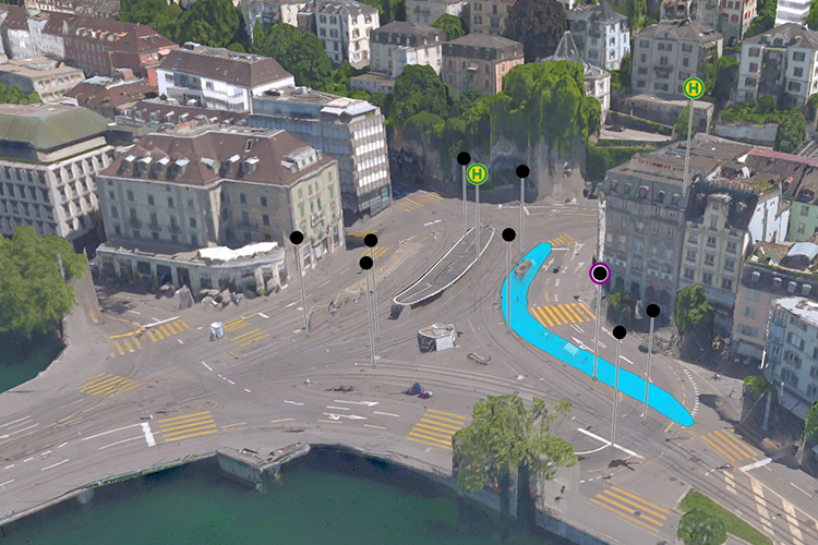
Watch this on-demand webinar to learn how Hexagon can help public transportation organisations to overcome these challenges and efficiently manage their data, workflows, and transit networks. By combining all asset and spatial data into an integrated transport network information system and common operational picture, organisations can avoid data duplication and ensure users have access to accurate and up-to-date information across the enterprise. Additionally, Hexagon’s 3D and AI capabilities allow departments to go beyond a simple map to create an advanced digital twin of their city’s entire public transportation system, from stops, track and switches to ticket machines, benches, and garbage cans.
In this webinar you’ll discover how to:
- Use artificial intelligence for predictive maintenance of the network
- Leverage 3D object detection
- Easily plan and execute infrastructure maintenance
- Efficiently coordinate construction works
- Optimize connections of different transportation lines
- Promptly manage incidents
- Integrate new mobility services
Register
Register to watch this on-demand webinar
Speakers
Speakers:


Robert is global transportation solution manager for Hexagon’s Geospatial division. He joined Hexagon in 2011 as transportation application engineer after obtaining a diploma in (Human) Geography and Informatics from the University of Augsburg in Germany.


Luzius is solution architect for Geo-Ops systems at Hexagon’s Geospatial division, in charge of technical business development in the Americas. Before joining Hexagon in 2009, he was a project manager in the market development division of Zurich Urban Transport Company (VBZ). Luzius holds a Master of Science in Geomatics Engineering from the Swiss Federal Institute of Technology in Zurich with specializations in Geoinformatics as well as in Urban and Traffic Planning.
Related topics
Digital Twins, Digitalisation, Electrification & Cabling, Infrastructure Developments, Passenger Experience/Satisfaction, Passenger Information Systems (PIS), Signalling, Control & Communications, Track Systems


